Severe weather threat has been upgraded to a Moderate Risk over much of the region for Friday afternoon through early Saturday morning...
...Flash Flood Watch remains in effect for the extreme northern portions of the region from noon on Friday through 7 am Saturday...
Timing and Overview:
A deep upper-level trough and strong cold front will begin moving into the Southern Plains during the day Friday. Ahead of these features, the threat of severe thunderstorms will increase on Friday afternoon and especially Friday night into the predawn hours Saturday morning. A Moderate Risk of severe thunderstorms covers much of the region while the remainder of the area is included in an Enhanced Risk (see graphic).
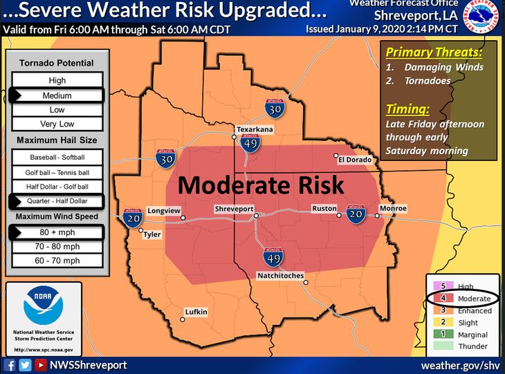
-- Impacts: By Friday afternoon, discrete supercell thunderstorms will be possible which could produce tornadoes (some strong, long-track tornadoes are possible), along with damaging wind gusts and large hail. By late Friday evening into the overnight hours, storm mode will transition to a widespread damaging wind threat with embedded isolated tornadoes as a squall line rapidly moves across the Four-State Region from the west.
The NWS/SPC confidence is higher with this damaging wind threat overnight compared to the tornado threat with discrete supercells Friday afternoon.
Keep in mind most of this event will take place during the evening and overnight hours so that poses an additional danger with warnings expected to continue well into early Saturday morning an additional danger with warnings expected to continue well into early Saturday morning.
.jpg)


 Click For Louisiana
